St. Julien Road Reconstruction
Consultation has concluded
The Town of Banff is scheduled to reconstruct and enhance St. Julien Road between Wolf Street and St. Julien Way in 2022.
Consultation is now closed
The goal of the reconstruction is to upgrade the utilities under the road, enhance the safety of drivers, pedestrians and cyclists, and to improve the function of the road, its shoulder area and its connections to Wolverine Street and Grizzly Street.
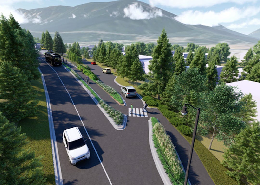
The work will include adding a sidewalk, replacing aging underground water and sewer utilities and light poles, adding landscaping elements, and improving the road surface, drainage and snow storage. The project will completely excavate the road and sidewalk from April to October in 2022, and final surface completion will occur in spring 2023. The Tunnel Mountain trailhead parking lot is not on Town land, and is not part of this project, but access to the lot from the road and sidewalks are part of this project.
The project team has developed some preliminary concept options to be used as a starting point for decisions, and refinements will be made through stakeholder engagement and the on-going technical review. These options are based on the Banff Streetscape Design Guidelines for this type of road. They have also been designed with consideration given to the unique characteristics of St. Julien Road, such as its width constraints and slope challenges.
Project Timeline

Sign up here to receive email notifications about upcoming activities on the St. Julien Road project.
Project Information
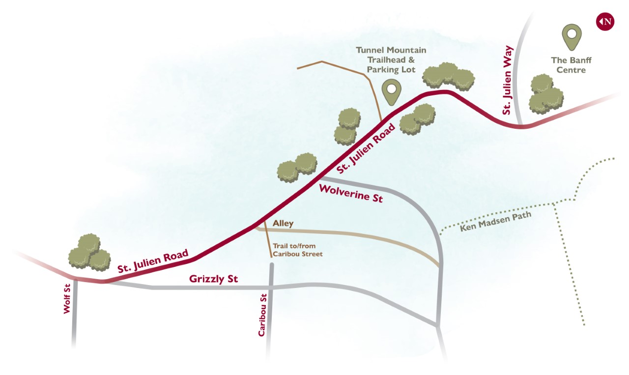
Map above shows the project area. St. Julien Road is being reconstructed from Wolf Street to St. Julien Way.

St. Julien Road is classified as a Connection Street with the sub-classification of Destination. Connection Destination Streets are designed to prioritize walking, cycling, transit and car travel, accommodate heavy vehicles to a moderate degree, and put low to no priority on parking. Please refer to page 9 and 10 in the Discussion Guide for more information.
The options being considered as they relate to landscaping are focused primarily on how the sidewalk/trail will be separated from the road. The lower cost option would be minimal to no landscaping, with a curb separating vehicles and pedestrians. The other option would be to provide some landscaping between sidewalk/trail and the road, which would present some upfront costs and on-going investment for maintenance.
There is also the possibility of including other street amenities, aesthetics and enhancements, such as benches, bike parking, etc., that could enhance the area but would also come with a price tag.
Please refer to page 11 in the Discussion Guide for more information on the landscaping options.
Two options are being considered to upgrade the intersection of St. Julien Road and Grizzly Street, and within both options there is the possibility of creating a mini park (or parkette) with a range of amenities. This section refers to page 12 and 13 in the Discussion Guide. Grizzly Street connection
Option 1A Close access to/from St. Julien Road at Grizzly Street and construct a cul-de-sac on Grizzly Street to allow vehicles to turn around.
Benefits: This is the safest option for pedestrians. The closure would also reduce the amount of paved surface in the area and reclaim some land for more greenspace.
Trade-offs: There would be no access to/from St. Julien Road to Grizzly Street. The cost for this option is more expensive than Option 1B.
Grizzly Street connection Option 1B Narrow and upgrade the intersection, keeping access to Grizzly Street for southbound traffic only.
Benefits: This design narrows the intersection significantly and improves the angle of the road for greater pedestrian safety. This option is less expensive than Option 1A and maintains access to Grizzly Street.
Trade-offs: Grading for the sidewalk presents a design challenge and requires a retaining wall to accommodate the sidewalk/trail.
Two options are being considered to upgrade the intersection of St. Julien Road and Wolverine Street. This section refers to page 14 and 15 in the Discussion Guide.
Wolverine Street Connection Option 2A: Close access to/from St. Julien Road at Wolverine Street and construct a turn-around at the end of Wolverine Street.
Benefits: This is the safest option for all users, particularly pedestrians, because it removes the crossing point at the intersection. It also solves some steep grade issues. The cost for this option is similar to Option 2B.
Trade-offs: This option removes access to/from St. Julien Road.
Wolverine Street connection Option 2B: Narrow the intersection to be a one-way street either from southbound St. Julien Road onto Wolverine Street OR from Wolverine Street onto northbound St. Julien Road.
Benefits: This option maintains access to Wolverine Street for southbound traffic (traveling uphill along St. Julien Road) OR for left turns for northbound traffic traveling downhill along St. Julien Road. This option also reduces the distance of the pedestrian crossing. The cost for this option is similar to Option 2A.
Trade-offs: This option creates challenges for the construction of the St. Julien Road sidewalk/trail and some steep grade issues would need to be resolved.
While there was originally some discussion about closing this lane, it has been determined that it will remain open. There is the option, however, of converting the lane into a one-way access onto St. Julien.
This section refers to page 16 in the Discussion Guide.
Benefits: The benefit of converting the lane to a one-way onto St. Julien Road is that it maintains the ability to exit the lane while minimizing non-local traffic.
Trade-offs: Access to the lane is provide from Wolverine Street only, restricting access options for property owners.
Improvements to the trail that connects Caribou Street to St. Julien Road are being considered. Currently the trail is a narrow (approx. 1m) gravel path with stairs on the steep sections. Potential improvements could include widening the trail, formalizing the bottom trailhead and improving the connection to Caribou Street. Leaving the trail as it exists today is also an option.
Please refer to page 17 in the Discussion Guide for more information about the Caribou Street trail.
St. Julien Road was named in honour of the Battle of St. Julien which took place in World War 1. On April 24, 1915, the Canadian First Division played an important role in defending against the first poison gas attacks by Germans to the Western Front. There is an opportunity to create an interpretive kiosk or plaque along St. Julien Road telling the story about the name and the importance of St. Julien.
Please refer to page 18 in the Discussion Guide for more information about the name St. Julien.
Who's Listening

Documents
-
 St Julien Council Report May 10.pdf (1.49 MB) (pdf)
-
St Julien What We Heard Report - Public Feedback.pdf (2.16 MB) (pdf)
-
St Julien Council Report PowerPoint.pdf (2.2 MB) (pdf)
-
St. Julien Road Reconstruction Overview - PDF (Used in Feb 25 resident presentation).pdf (21.5 MB) (pdf)
-
Discussion Guide - St Julien Road Reconstruction WEB version.pdf (4.13 MB) (pdf)
